
Tongariro Crossing today! 🙂
The plan was breakfast at 6.30am and catch the bus at 7.30am. This was the view of Ruapehu (near Ngauruhoe) just before 7.30am. Hmmmm.

The bus dropped us off at the Mangatepopo car park (about 1100m elevation). It is easier to walk from the Mangatepopo car park to the Ketetahi car park as the climb is less than if walking in the other direction.
We got out of the bus and immediately put on warmer and windproof clothes, it wasn’t warm and the wind was blowing.
Us at the start at about 8:10am. Noel, Me, Karen, Lynne and Keith.

Noel, Paul, Karen, Lynne and Keith.

Information at the start of the track.

This is the elevation chart which my GPS recorded for the walk. We did go off the track slightly for a nicer place to stop for a mid morning break. We walked from 3678ft (1121m) up to 6045ft (1842m) and down to 2504ft (763m).

At various places along the track we’d come across warning signs about the volcanic activity. The cloud is still low.

A very early point to stop at a toilet if needed. One more, at Soda Springs, after this before Ketetahi. Keith and Lynne ahead.

Steady climbing. Noel and Paul.

You can see the track we’ve come along.

Still low cloud. Ngauruhoe to the right.

A view of where we’ve come from, Ngauruhoe to the left.

Lava flow.

A brief stop to look at the view of a cloud-hidden Ngauruhoe. Noel, Lynne, Keith, Karen and Paul.

09:10am. Approaching Soda Springs, with the toilets in the distance. Lynne and Karen in the foreground. Still cloudy…

09:30am. One of the warning signs, checking in this case if you’re prepared and fit enough! Me and Noel.

Karen and Paul.

We started somewhere down there!

Paul pointing something out to Noel.


Still going upwards…

Another view of where we started from. A steady climb.

Still going up and still cloudy 🙂 Paul and Noel.

Ngauruhoe still under cloud.

An information sign.

Ngauruhoe with lava in the foreground.

View of where we came from.

Noel.

About 10:10am.

A brief pause and then we’re off again.

As we were steadily climbing upwards we were passed by 2 runners going up! Shortly after this picture they ran towards and past us on the way down, chatting easily as they ran. I’m not playing any more! 🙂
The track leads to the lower part of the ridge in the picture but we walked off it to the left to have a morning break.

Just about to leave the track to the left.

Low cloud and some wind. Looking at the ridge we’ll walk to.

Wait for meeeeeee…

10:25am. Out of the wind a bit.


Keith, Lynne and Karen walking across the crater from our break-stop to rejoin the track.

Looking back at Ngauruhoe still in cloud, with people on the track.

After rejoining the track, just before climbing the ridge, there was a crater.

Lynne, Noel, Me and Karen.

Lynne, Noel, Karen and Paul.

Yup, Ngauruhoe still in cloud.

Having climbed the ridge from the crater where we stopped for a break, this was the view over the other side.

And from the ridge this was the view of the way we’d come. Our break-stop was to the right off the track.

10:55am. Just a bit nippy!

A couple of views from the ridge.


STILL going up! Ngauruhoe STILL in cloud! 🙂

11:15am. From this point we could see the Red Crater which was pretty impressive.


The Red Crater to the right with more track to climb to the left.

Karen, Paul and Keith.

Noel in front of the Red Crater.

Karen, Lynne, Keith, Paul and Noel.

Me beside the Red Crater.

At this point Karen, a great wildlife aficionado, recognised a lesser-spotted Kiwi so I took a photo as it is unusual to find them on these slopes. 😆

Paul and Noel admiring the Red Crater.

Guess what?! Still going up…

The Good Old NZ Summer! 🙂 Karen, Noel and Lynne.

Paul and Karen in the cloud.

Another view of the Red Crater.


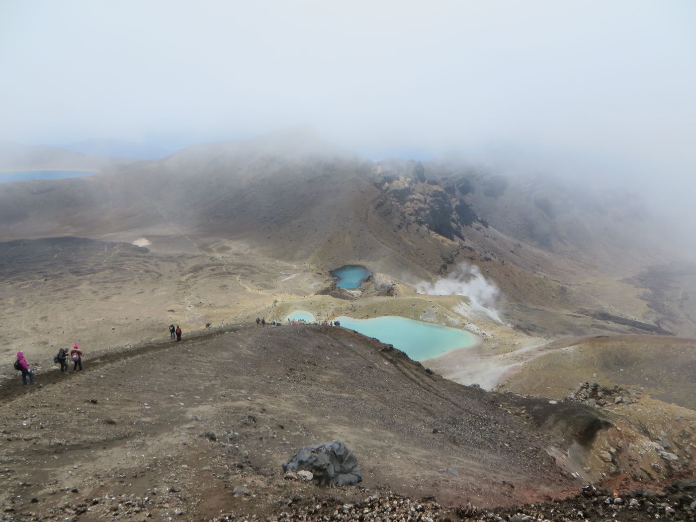
11:25am. A view from the top, looking at the track we will take which leads to the Blue Lake.

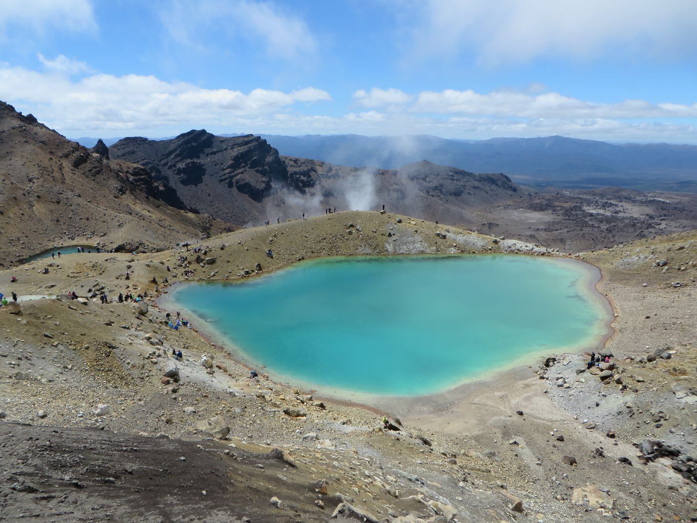
11:30am. View from the top, looking down on the Emerald Lakes. Still cloud around.

Paul strapping into his paraglider prior to launch.

On the way down to the Emerald Lakes. This bit was fun – the earth was loose so the technique was to bound down quite quickly at times.

Lynne and Keith waving in the background.


The Blue Lake, with Lake Taupo in the very far distance.

Me and Noel.

From our position (above) we took a picture of Keith, Lynne, Paul and Karen.

11:45am. Beautiful! We stopped beside this lake for lunch.
11:50am. I had lots of small stones in my boots from the descent on the loose earth so the lunch stop was a relief!

You can see the trail we came down.


12:10pm. On our way again.


The path we’ll follow is to the left.

Another signpost with the intrepid four marching along. 🙂

A view of where we had walked from. The path goes to the highest point.

If you look carefully you can just see people on the ridge ahead. Another climb coming up…

12:30pm. Climbing up the ridge we suddenly realised that Ngauruhoe was finally starting to lose its cloud! You can see lots of people on the path which we’d just been on.

Cloud going…

…going…

…gone! Finally, no cloud on top of Ngauruhoe 🙂
Me and Noel.

Woohoo! 🙂

A photocall had to be done 😀


Me!

Noel and Me.

Keith and Lynne.

Karen and Paul.

12:40pm. After that excitement we then walked beside the Blue Lake.

Paul.

A panoramic shot.

Bye-bye Ngauruhoe.

1:00pm. From here we started a steady descent (with a few, odd uphill bits thrown in). The walk was a bit less interesting but the views of Lake Taupo were great and it was still a lovely walk. Lake Rotoaira with Lake Taupo in the background.

Well, after all that walking, I’m NOT turning around NOW! 🙄


Another view of Lake Rotoaira and Lake Taupo beyond. Note the ‘cloud’ on the side of the hill – that’s actually steam coming out of the side of the mountain!

See? Told you!


Towards the centre of the picture you can just make out a road coming from this direction to a road going across the picture. We are heading down there!

1:15pm. Steam venting in the background, thousands of hardy walkers requiring rucksacks, water and good boots and there’s a digger halfway up the mountain. But of course! I’m not surprised at anything here! 🙂

You can see the mountain to the north of Taupo in the far distance.


What a great walk. I’d like to say this was the easy bit, going downhill, but my toes were hurting…

1:55pm. At Ketetahi.


The intrepid four still making their way down.


2:20pm.

2:40pm. Yup, still going…

3:35pm. FINALLY! 😎


The 6 of us. Personally, I’d seized up a bit so it was interesting getting up from a sitting position to move for this photo. There was NO way I was going to be able to crouch down again! 😯

Lynne had had an interesting end to her walk – she’d witnessed someone fall over on the gravel path and cut themselves quite badly so her First Aid Training kicked in and she cleaned and bandaged the wound and sorted out an ambulance.
The bus was crowded so we stood, only for the 6 of us to be decanted into another, empty bus. Cool! The windscreen was absolutely covered in large bug strikes and it turned out it was the result of flying into bees!
Once we were on the road I took a few pictures from the bus. Ngauruhoe to the left and Ruapehu to the right.


The view from the hotel of Ruapehu – a bit different to this morning and to the previous evening!

The view from the hotel of Ngauruhoe and Tongariro.

After a beer and outside spa pool at the hotel we had a rest before going to the Chateau Tongariro hotel for dinner. A big treat but we felt it was well-earned! This is the view of Ngauruhoe from the car park.

We had drinks before dinner, looking out at Ngauruhoe. There was going to be the Tussock Traverse event the next day, hence the scene out of the window.

Karen, Lynne, Paul, Keith, Noel and Me.


The meal was superb and it was a great end to a memorable day and a fantastic walk!